ADVENTURE HIKES AND CANYONEERING
IN THE SAN GABRIELS
© Christopher Earls Brennen

|
|---|

|
Hike A1. Bee Canyon
- Hiking time: 3 hours 20 minutes
- Estimated hiking distance: 2.7 miles
- Elevation gain: 580 feet
- USGS Topo Maps: Sunland
- Difficulties: Three straightforward rappels of 50ft, 25ft and 30ft
- Special equipment: Rappelling equipment including 160ft rope, 15ft webbing, one rappel ring, harnesses and helmets
-
ACA Rating: 3A II

Characteristics
Pacoima Canyon drains the northwest corner of the San Gabriel mountains, flowing west between two subtantial ridges before slicing south through precipitous terrain to emerge into the San Fernando Valley. In its gentler upper reaches it is a broad and gradual canyon but with steep walls created by the Mendenhall Ridge on the south and the Santa Clara Divide ridge to the north. Both ridges can be accessed using dirt roads called, unsurprisingly, the Mendenhall Ridge Road and the Santa Clara Divide Road. These allow access to a series of steep lateral canyons some of which make for good off-trail adventures. In this hike we drop into Bee Canyon from the Santa Clara Divide Road and descend into Pacoima Canyon. Three easy rappels are needed near the bottom and then a little bushwhacking takes you to Pacoima Canyon. From there you hike out of Pacoima to the Dillon Divide trailhead using the old fireroad that was also followed in the Laurel Canyon hike. Southeast-facing and with mostly desert like vegetation, Bee Canyon is best for a winter day hike.
Trailhead
This hike requires a car shuttle. First leave a vehicle at the small roadside parking area at Dillon Divide (34o20.68'N 118o20.97'W and elevation 2770ft), the high point on Little Tujunga Road. To get there from the 210 Freeway in Sunland, take the Osborne Steet offramp, drive north and turn left at the first traffic light. Osborne Street leads into Little Tujunga Road which proceeds up Little Tujunga Canyon past many horse ranches. At the head of the canyon, the road switchbacks up to Dillon Divide, about 7.5mi from the 210 Freeway. Just beyond the summit note the metal gate on the dirt road branching off to the right. Leave the first vehicle there and continue west on the road for 4.4mi where, just past Bear Divide, you turn right onto Santa Clara Divide Road. Drive 2mi up this asphalt road to where there is an overlook on the right at the top of the ridge. Actually there are two overlooks, separated by less than 100yds and you want the second of these which has a grove of pine trees on the opposite side of the road. Park in the turn-off on the right (at 34o21.54'N 118o21.98'W and elevation 3440ft).
Hike
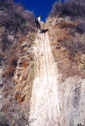
|
|---|
| First rappel in Bee Canyon |
Then, 1hr 10min into the hike at an elevation of 2480ft you arrive at the top of the first of three rappels. These occur one after the other and allow the rope to be fed straight through. The first rappel involves a vertical drop of 50ft and, like the others, has an easy entry. The nearest anchor is a tree on the left about 20ft upstream from the lip. It is probably best to use a rappel ring here. This first rappel takes you down to a broad shelf and the top of the second rappel, a modest 25ft drop for which you should use the tree on the right as the anchor. The top of the third rappel is only 20yds downstream. Use the large tree to the left of the streambed for this 30ft descent. At the bottom you can stow away the rappelling gear. You should reach this point about 2hr after starting the descent.
Below the third rappel, there is an easy downclimb of a rocky cascade and then some bushwhacking as you approach the junction of Bee Canyon with Pacoima Canyon at 34o21.13'N 118o21.51'W. Push through the brush to get to the river (or riverbed for it often dries up at the end of the summer) and turn upstream. You should now be about 2hr 15min and 0.7mi from the drop-in point and at an elevation of 2230ft.
As you proceed up Pacoima Canyon, try to locate the brush-free route and watch for the trail that climbs up out of the canyon on the right hand side. You should see the two first long switchbacks high above you and then be able to cross the low brush on a bench to the right in order to intersect the trail where it starts to climb the right wall (about 34o21.26'N 118o21.22'W). It takes about 25min to reach the trail after leaving Bee Canyon.
The trail starts at about 2270ft, 1.1mi from the start of the hike. After the first 100yds or so it is clearly following the remnants of an old dirt road that switchbacks twice and then contours southwest as it climbs out of the canyon. After 35min and 1.2mi you come to the junction with the Mendenhall Ridge Road at 34o20.91'N 118o21.18'W and an elevation of 2850ft. Continue southest down the Ridge Road; it is only a 10min walk back to Dillon Divide trailhead (34o20.68'N 118o20.97'W). The hike covers a total of 2.7mi with a hiking time of about 3hr 20min.
Last updated 1/15/02.
Christopher E. Brennen