ADVENTURE HIKES AND CANYONEERING
IN THE SAN GABRIELS
© Christopher Earls Brennen

|
|---|

|
Hike H6. Bull Canyon
- Hiking time: 9 hours
- Estimated hiking distance: 6.8 miles
- Elevation gain: 3060 feet
- USGS Topo Maps: Cucamonga Peak
- Difficulties: 7 rappels ranging up to 140ft in height.
- Special equipment: Rapelling equipment with a 160ft rope, a 160ft recovery cord, 60ft of webbing, 7 rappel rings.
-
ACA Rating: 3A IV

Characteristics
The precipitous southern cliffs of Cucamonga Peak tower nearly 9000ft over the city of Rancho Cucamonga in the eastern San Gabriel valley and provide a majestic background for those in the valley below. Up near the summit the cliffs are awesome but highly fractured, making climbing very difficult and dangerous. Lower down the slopes are more stable, the canyons older and more weathered. Two canyons in particular dominate, namely Deer Canyon and Day Canyon and these carry most of the run-off from the southern slopes of Cucamonga Peak. Indeed during major storms, these canyons become raging torrents of water, mud and rock. As a result, they are broad boulder-filled washes during the rest of the time. This adventure takes you up the boulder highway of Deer Canyon to where an old road crosses the wash. This now-abandoned dirt road used to allow off-road travel from Cucamonga Canyon, across the south face of Cucamonga Peak and down to Sevaine Flats and thus to Lytle Creek. It is now so damaged that it is unlikely to be made passable again. But it allows easy hiking and from the Deer Canyon crossing we hike east for several miles to the head of Bull Canyon. The descent of Bull Canyon provides an exciting and challenging canyoneering adventure for it contains a series of spectacular waterfalls, usually dry or with a trickle of water. The final series of large rappels, 100ft and 140ft in height are particularly exciting. At the bottom Bull Canyon exits into Deer Canyon and you return to your starting point. The hike is good at any time of year though, in the summer, it may be too hot.
Trailhead
From the 210 freeway in Rancho Cucamonga, exit at the Haven Avenue offramp and drive north on Haven to where the road narrows to a single lane. If the single lane road is closed park here. If not, continue up the single lane road to a point just past a turn to the left where there is a large dirt parking area on the left side of the road (34o10.31'N 117o34.52'W, elevation 2550ft). Park here. Note the gated asphalt road that forks off to the northeast that is the route for the start and end of the hike.
Hike
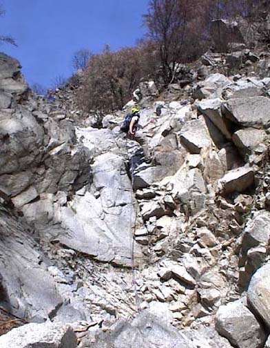
|
|---|
| Second rappel |
(Photo by Bob Shear) |
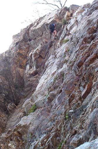
|
|---|
| Penultimate 100ft rappel |
(Photo by Nathan Wozny) |
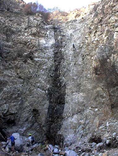
|
|---|
| Last 140ft rappel |
(Photo by Bob Shear) |
Another short hike brings you to the edge of the final, big drop-off (34o11.22'N 117o34.09'W, elevation 3770ft) consisting of a 30ft downclimb followed immediately by rappels of 100ft and 140ft. From the top this presents an awesome prospect. The first 30ft drop does not have an obviously safe rappel anchor but provided there is not much water flowing it is fairly easy and safe to downclimb by chimneying down the slot where the water flows (the alternative would be to build a deadman anchor). This downclimb brings you to a broad flat place that ends in a dramatic 100ft drop. A tree on the right side of the lip provides a good anchor for this vertical rappel down to another flat place where the canyon turns sharp right and arrives at the top of the final precipitous 140ft rappel. A large boulder near the middle of the lip makes a good anchor for this exciting final descent.
You should reach the bottom of this last rappel (elevation 3500ft) about 8hr and 5.6mi from the start. Here you can stow your gear for there are only a few short downclimbs between this point and the mouth of Bull Canyon. At the mouth (elevation 3120ft), turn left and hike Deer Canyon wash to the remains of an old gauging station(?). From here cut across to the right to the twin water tanks you noted in the morning and follow the asphalt road down to your parked vehicle (34o10.31'N 117o34.52'W, elevation 2550ft). You should complete the 6.8mi hike in about 9hr.
Last updated 7/30/99.
Christopher E. Brennen