ADVENTURE HIKES AND CANYONEERING
IN THE SAN GABRIELS
© Christopher Earls Brennen

|
|---|

|
Hike C2. Casada Canyon
- Hiking time: 7.5 hours
- Estimated hiking distance: 5 miles
- Elevation gain: 1780 feet
- USGS Topo Maps: Condor Peak
- Difficulties: 3 rappels of 40ft, 180ft and 110ft, some tough bushwhacking
- Special equipment: Helmet, harness and rappeling gear; 200ft rope, 200ft recovery cord, 25ft webbing, 3 rappel rings, clothing for bushwhacking
-
ACA Rating: 3A IV

Characteristics
|
|---|
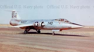
| Casada's F-104 Starfighter |
The adventure begins at the summit of Josephine Peak and descends the canyon directly to the south of that peak, hoping along the way to find signs of that high speed impact. The descent of Casada Canyon consists of three distinct phases, a section of very tough, even brutal, bushwhacking, an attractive and open middle section with some big rappels and then a final section of lighter bushwhacking. A little water runs in the lowest section. This hike is best on a winter day for otherwise the south facing upper sections could get very hot indeed.
Trailhead
If you wish to set up a vehicle shuttle for the 0.5mi trip up the road to Clear Creek Junction at the end of the hike then, starting at Clear Creek Junction, drive the 0.5mi west on the Angeles Forest Highway to a point where there is a pullout on the right and a corrugated metal drainage structure stands in the canyon just below the highway on the right side. Park the return vehicle here at 34o16.42'N 118o9.65'W and an elevation of 3490ft.
Then, in the other vehicle(s) return to Clear Creek Junction where the Angeles Forest Highway splits off from the Angeles Crest Highway 9.4mi north of the 210 Freeway in La Canada Flintridge and 6.2mi north of the Angeles Crest Forest Service Station. Park in the dirt pullout at Clear Creek Junction at 34o16.22'N 118o9.21'W and an elevation of 3650ft.
Hike
|
|---|
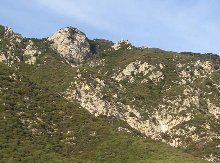
| View from the bottom: start is just to the left of the cliff-faced |
| peak, Casada Point, and the 180ft rappel is in the lower right (in white) |
It takes about 1hr 10min to reach this ridgetop junction. Turn left and continue up the Josephine Fireroad as it climbs toward the Peak itself. The final leg of this ascent circles around below the Peak and you want the overlook on the southwest directly below the summit where the ridge rising toward the peak from the west meets the fireroad. You should reach this drop-in point at 34o17.11'N 118o9.25'W and an elevation of 5430ft about 2hrs and 3.9mi from the start. Gear up here and prepare for the descent of Casada Canyon.

|
|---|
| 180ft rappel |
There are several possible routes through the first section. One explored route is to hike a short distance down the ridgetop from the drop-in to the first rocky promontory (Casada Point) and then continue about 100ft down the ridge to 34o17.09'N 118o9.36'W and an elevation of 5260ft) where a rough use-trail proceeds to the left, appearing to contour around the bottom of the cliff on your left. This is the southern face of Casada Point, the highpoint in the photograph taken from the bottom. This explored route only traverses a short distance along the cliff bottom before heading straight down through the dense brush. If you can find this already travelled route this may be the way to go but the route still involves some brutal bushwhacking. If you go this way, then about 2hrs after the drop-in, you should be able to reach an open streamcourse at about 4800ft where several gullies come together.
[Before continuing we should mention several other unexplored options that might allow easier passage through this upper section. One would be to walk out to the peak of Casada Point and rappel down the cliff face as far as possible. Viewed from below it appears that there is a scree slope below the cliff which could ease the descent and postpone the bushwhacking. Another possible alternative route would be to stay close to the bottom of the Casada Point cliff for longer than the explored option and to rappel steep rock where needed.]
Resuming description of the explored option at the confluence of the gullies, the going is suddenly much easier though still steep. After dropping another 200ft or so the gradient eases and you enter the attractive middle section of the canyon. A little further downstream at an elevation of 4540ft you will arrive at the top of the first rappel about 4.5hrs from the morning start. This is a 40ft rappel down sloping rock from a big, shady tree at the top. This is followed by a number of easy downclimbs over white bedrock. Then, just a short way downstream, the canyon gradient steepens and at 4210ft and 5hrs from the start you arrive at the top of the steep drop near the bottom of Casada Canyon. This begins with another series of easy friction descents over white bedrock that culminates at 4200ft at the lip of a big 180ft rappel over the same shining white rock. The anchor for this big sloping rappel is a sturdy bush on the left near the lip. You descend into a narrow bush-choked slot but it is only a few yards to the top of the last rappel, a vertical 110ft drop from a bush anchor on the right. Again you descend into a bush-choked canyon bottom.
You should reach the bottom of these rappels about 6hrs into the hike. Downstream there are two long, sloping downclimbs of about 40ft before all that is left is a long, brushy hike out that concludes when you encounter a conduit for the stream and climb a few feet up to the road and your return vehicle. The end is at 34o16.42'N 118o9.65'W and an elevation of 3500ft. The hike should take about 7.5hrs during which you cover about 5mi.
Last updated 2/20/07.
Christopher E. Brennen