ADVENTURE HIKES AND CANYONEERING
IN THE SAN GABRIELS
© Christopher Earls Brennen

|
|---|

|
Hike D15. East Fork of Santa Anita Canyon
- Hiking time: 8 hours
- Estimated hiking distance: 6.9 miles
- Elevation gain: 2400 feet
- USGS Topo Maps: Mt. Wilson
- Difficulties: One 70ft rappel, one steep 1500ft ridge climb with bushwhacking
- Special equipment: Rappelling gear, 200ft rope, 8ft webbing and one rappel ring
-
ACA Rating: 3A III

Characteristics
One of the prettiest, untravelled canyons in the front range of the San Gabriels is the East Fork of Santa Anita. Though the bottom end is easily accessed from the popular and well-travelled trail from Chantry Flats to Sturtevant Falls, few hikers venture up the East Fork. This adventure hike begins at Chantry Flats, drops down into the main canyon via the established trails and then climbs a steep ridge up the east wall to access the remote Upper Clamshell dirt road. It then travels north on the Upper Clamshell to a point where you can drop down into the East Fork of the Santa Anita. You then descend the East Fork, a hike that involves much bouldering and one substantial rappel down a vertical 70ft waterfall.
This hike is probably best in the winter or spring when the climb up the ridge is not too hot. On the other hand there are many marvellous swimming holes in the East Fork that would be great in the summer. One drawback to this hike is the large quantity of poison oak in the East Fork; protection is recommended for those who may be sensitive.
Trailhead
Drive north on Santa Anita Avenue in Arcadia, continue up the mountain road to Chantry Flats (34o11.77'N 118o1.35'W and elevation 2100ft) and park there.
Hike
Beginning in the Chantry Flats parking lot (34o11.77'N 118o1.35'W and elevation 2100ft), follow the asphalt road descending into the canyon. After about 150yds take the trail leaving the right side of the road and follow this down to the Santa Anita river. Crossing to the east side, continue downstream, following the canyon bottom trail to Hermit Falls (34o11.49'N 118o1.05'W and elevation 1460ft) which you should reach about 35min and 0.9mi from the start. Take a moment to explore and admire these lovely pools and waterfalls.
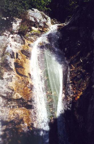
|
|---|
| East Fork Waterfall |
After the tough steep climb (and bushwhack) up the ridge, it is a relief to turn left and hike north along the Upper Clamshell. This is a very rarely travelled dirt road that branches off from the Rincon/Red Box road at an elevation of 4720ft (where it is gated to prevent vehicular access) and descends for about six miles to a valley overlook at 2900ft where there is a watertank but little else. Perhaps the original intention was to build a road down to Arcadia but this never happened.
The road is in remarkably good condition considering how rarely it is travelled. The surface is smooth and I only noticed one place where fallen rocks would prevent vehicle passage. The gradient is also quite gradual. Coupled with the pleasant wooded surroundings, this makes for a most enjoyable hike. The road makes two large incursions into the hillside to contour around the head of two canyons and then rounds a headland with a great view of various forks of the Santa Anita. You then cross above a saddle some distance below the road to enter the East Fork of the Santa Anita, high on that canyon's south wall. Just beyond that saddle, it is important to identify a place where the road turns sharply east. That identification is made easier by the fact that just around the corner you enter a "tunnel" of woods on the heavily forested north-facing slope. The drop-in point for the descent into the East Fork is just 30yds beyond the corner at 34o12.31'N 118o0.22'W and an elevation of 3800ft. It is currently marked by a duck beside a metal water chute on the left side of the road. If you miss this waypoint you will pass a much larger concrete water chute several hundreds of yards further on. Do not descend the gully with the concrete chute but return to the less conspicous metal chute. You should reach the drop-in point about 4hr after leaving Chantry Flats. It is 2.2mi from the point where you accessed the road and 4mi from the start.
Leaving the road, the cross-country route lies down the steep but leafy and open slope in the forest. If you head straight down you will soon drop into a shallow gully that develops into a small canyon that eventually meets the East Fork. The descent takes just 40min and

|
|---|
| Lateral waterfall in chasm |
There are three possible ways to descend into the chasm. Two involve rappelling about 70ft down the falls using as anchors trees that are a short way back from the lip. One tree some distance back leads to rappel down the falls and will usually result in a wet descent. Another tree off to the right that requires a contour across a steep earthen slope (a belay is advisable here) will lead to a rappel down a dry chute to the right of the main stream. In either case you must wade through a knee deep pool at the base of the waterfall. A third possibility is to climb around the falls by retreating a short way upstream to where you can climb the left (south) bank onto a shoulder above the falls and the chasm. A faint use-trail

|
|---|
| Pool in lower canyon |
Downstream of the chasm there are many smaller waterfalls and lots of lovely, deep pools. The going is slow since you must find your way around and down through these many obstacles. But none require technical equipment. The descent through this lovely stretch of canyon takes about 1.5hr. You should reach the end of the East Fork about 7.5hr after the start having travelled about 5.6mi. Here the East Fork meets the main Santa Anita canyon and you access the popular and well-travelled dirt road from Chantry Flats to Sturtevant Falls at 34o12.78'N 118o1.04'W and an elevation of 1940ft.
From here it only remains to hike that popular trail down the main canyon and then up the asphalt road back to Chantry Flats. The total hiking time should be about 8hr in which you cover about 6.9mi.
Last updated 4/25/01.
Christopher E. Brennen