ADVENTURE HIKES AND CANYONEERING
IN THE SAN GABRIELS
© Christopher Earls Brennen

|
|---|

|
Hike A2. Laurel Canyon
- Hiking time: 5 hours
- Estimated hiking distance: 7.9 miles
- Elevation gain: 1420 feet
- USGS Topo Maps: Sunland
- Difficulties: Some downclimbing
- Special equipment: 60ft rope or webbing
-
ACA Rating: 2A III

Characteristics
Pacoima Canyon drains the northwest corner of the San Gabriel mountains, flowing west between two subtantial ridges before slicing south through precipitous terrain to emerge into the San Fernando Valley. In its gentler upper reaches it is a broad and gradual canyon but with quite precipitous walls created by Mendenhall Ridge on the south and Santa Clara Divide ridge to the north. Both ridges can be accessed using dirt roads called, unsurprisingly, the Mendenhall Ridge Road and the Santa Clara Divide Road. These allow access to a series of steep lateral canyons some of which make for good off-trail adventures. In this hike we drop into Laurel Canyon where it crosses Mendenhall Ridge Road and descend into Pacoima Canyon. Laurel is an easy, north-facing wooded canyon that is mostly brush-free and has just a few downclimbing challenges. It can be enjoyed in spring, summer or the fall before too much rain has fallen.
Trailhead
The trailhead is a small roadside parking area at Dillon Divide (34o20.68'N 118o20.97'W), the high point on Little Tujunga Road. From the 210 Freeway in Sunland, take the Osborne Steet offramp, drive north and turn left at the first traffic light. Osborne Street leads into Little Tujunga Road and soon proceeds up Little Tujunga Canyon past many horse ranches. At the head of the canyon, the road switchbacks up to Dillon Divide, about 7.5mi from the 210 Freeway. Just beyond the summit note the metal gate on the dirt road branching off to the right. Park in the roadside parking area beside the gate.
Hike
|
|---|
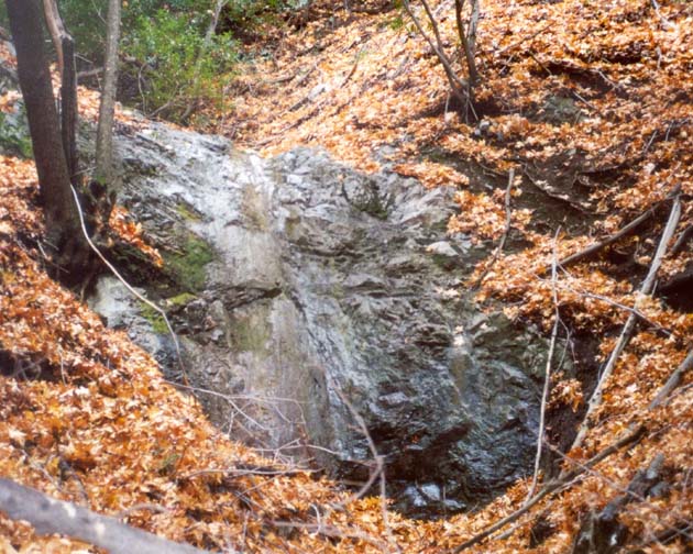
| Falls in Laurel Canyon |
In its upper reaches Laurel is a wooded but open canyon, and the off-trail descent is easy and pleasant. Indeed there are no distinctive landmarks until about 45min into the descent when you will encounter a straightforward 6ft downclimb at about 2940ft. Beyond this the canyon becomes a little more challenging with several downclimbs and occasional sections where a little bushwhacking is neccesary. At an elevation of 2730ft there are two 6ft steps with rock pools that require some careful downclimbing and these are immediately followed by a 20ft waterfall that can be bypassed using the dirt slope on the right. A short distance further and you will come to the trickiest obstacle on this hike, a 12ft waterfall in a narrow gate. This is more easily downclimbed than might appear - using the footholds on the center right. But some may wish to use a belay for which there are convenient large roots on the left wall. Others may choose to do a short rappel.
You should reach the bottom of Laurel Canyon (34o21.57'N 118o19.99'W and elevation 2510ft) about 3hr 15min and 4.4mi from the start. Here you are on a broad gravel wash that provides easy going as you turn left and head downstream. In the spring the river may be tricky to cross but it often dries up completely in the fall. The river meanders back and forth and, in several places, is close to breaking through to bypass a meander. As you progress a use-trail will begin to become evident. For several stretches it follows the remains of an old road that once reached far up into Pacoima Canyon. It is a very pleasant hike down this meandering canyon with many wooded benches and meadows on flats along the sides at the base of the steep walls. Two miles from the end of Laurel Canyon you should look for the exit trail. It proceeds up to the left on a large bench just after the streambed rounds a left turn where the bed is right up against the left-hand cliff. You should reach this waypoint (elevation 2270ft) about 4hr 15min and 6.4mi from the start.
After the first 100yds or so the trail is clearly following the remnants of an old dirt road that switchbacks twice and then contours southwest as it climbs toward the Mendenhall Ridge Road. Reaching that road at the first fork, it is then only a 10min walk back to the trailhead (34o20.68'N 118o20.97'W and elevation 2770ft). The hike covers a total of 7.9mi with a hiking time of about 5hr.
Last updated 12/3/01.
Christopher E. Brennen