ADVENTURE HIKES AND CANYONEERING
IN THE SAN GABRIELS
© Christopher Earls Brennen

|
|---|

|
Hike E4. Lower Devil's Canyon
- Biking time: 2.3 hours
- Estimated biking distance: 17 miles
- Hiking time: 7 hours
- Estimated hiking distance: 7 miles
- Elevation gain: 960 feet (bike) and 790 feet (hike)
- USGS Topo Maps: Waterman Mountain
- Difficulties: Some short rock climbs
- Special equipment: 20ft webbing
-
ACA Rating: 2A IV

Characteristics
This is an adventure hike that has considerable variety. The first part involves an easy 6mi bike ride along an asphalt road up a beautiful wooded canyon followed by a short ride up a steep incline, across a dam and along a dirt road. This leads to a modestly challenging hike with some scrambling over rocks. Since you will return by the same route, you can adjust the length of the adventure to the available time. If, on the other hand you are determined to reach the ultimate terminus of the hike, Devil's Canyon Falls, then you should be prepared for a day long outing with an early start and a late finish.
The off-trail part of the hike traverses the lowest section of Devil's Canyon between the Falls (see Devil's Canyon Loop) and the point where Devil's Canyon joins the West Fork of the San Gabriel River.
Trailhead
You begin by driving up Highway 39 above Azusa, passing the Morris and San Gabriel dams. Continuing north past the junction with the East Fork road and the off-road vehicle area, you arrive at the junction with the West Fork of the San Gabriel River. Here, just beyond the Forest Service Camp at Rincon, there is a small dirt parking area on the left to the south of the road bridge and a larger asphalt parking lot on the left to the north of the bridge. Park in either place, unload your bicycle and prepare for the ride up the West Fork. The starting point is the gate at the entrance to the narrow asphalt road up the West Fork which is just south of the road bridge (34o14.48'N 117o52.12'W and elevation 1580ft).
Bike ride
|
|---|
| Almost at end of Devil's Canyon |
After about 6mi you pass a pleasant flat where there used to be a campground, Glenn Canyon Trail Camp (34o14.44'N 117o57.14'W and elevation 2040ft). Half a mile further, the road suddenly steepens and it is a hard climb up about half a mile to the top of Cogswell Dam (elevation 2400ft). On the way you pass through the hamlet of houses belonging to the personel who tend the dam. When you reach the dam turn right at 34o14.60'N 117o57.85'W and cross over the top of the dam. At the other side turn left and follow the dirt road that contours along the north side of Cogswell Reservoir for a short distance before turning north and entering a large side canyon. At this point you are leaving the West Fork of the San Gabriel and entering Devil's Canyon. The dirt road continues up Devil's Canyon for about half a mile. At one point it forks; continue straight on the upper or right fork. A short distance beyond the dirt road becomes a trail following a narrow ledge some height above the canyon bottom. Soon, this ledge vanishes (at 34o15.24'N 117o58.43'W and elevation 2480ft) and you should hide your bicycle in the bushes and prepare to continue on foot. There are several places where it is fairly easy to climb down from the ledge to the stream.
Hike
Beyond this point there are only vestiges of a trail up Devil's Canyon. During the first few hundred yards of boulder hopping near or along the stream look out for the signs of the bighorn sheep herd that frequents this lower canyon. If you surprise them at the stream they will scamper straight up the steep canyon walls. It is a truly awesome spectacle, as they seem to defy the forces of gravity. Often they will halt about fifty feet up as if knowing that you cannot follow them there. Sometimes you will hear them high above you and, frustratingly, not be able to see them.

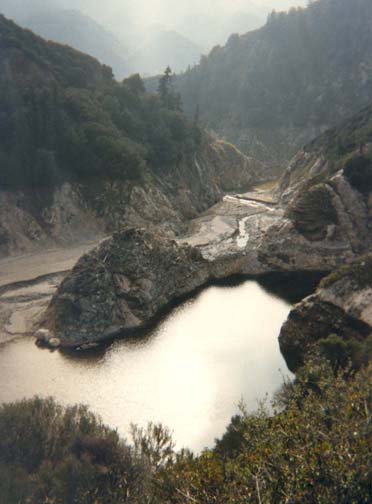
|
|---|
| Entrance to narrows |
It could be quite tricky to get above this small waterfall. Fortunately, there is almost always a log placed across the top of the waterfall that you can access from the rock on the left. Walking across this log allows you fairly easy access to the rock ledge on the right side upstream of the falls. Just beyond this there are several other places where you must climb up modest rock slopes past waterfalls. But soon, the canyon opens up again and the going becomes easier. About 0.3mi upstream there is a place where it is necessary to climb up on the rock to the right in order to get past a large pool but beyond this there is a long stretch of canyon with few special features.
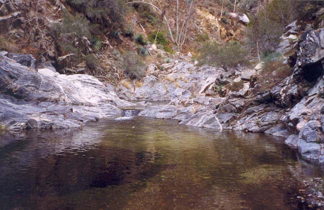
|
|---|
| Pool in lower Devil's Canyon |

|
|---|
| Lower Devil's Canyon Falls |
(Photo by Hugh Blanchard) |
But this is the limit of the hike defined here. If you have come this far, you will need to begin your return with little delay in order to be sure to reach your bicycle before sunset. It would be foolhardy to try and negotiate the lower part of this canyon in the dark. However, with a good bicycle light, it is not a problem to ride down the West Fork Road after sunset.
Last updated 7/30/99.
Christopher E. Brennen