ADVENTURE HIKES AND CANYONEERING
IN THE SAN GABRIELS
© Christopher Earls Brennen

|
|---|

|
Hike B2. Suicide Canyon
- Hiking time: 10 hours (6 hours by the Maxon Route)
- Estimated hiking distance: 8.5 miles (2.3 miles by the Maxon Route)
- Elevation gain: 2110 feet (1000 feet by the Maxon Route)
- USGS Topo Maps: Condor Peak, Pasadena
- Difficulties: 8 rappels up to 190ft
- Special equipment: 200ft rope, 200ft recovery cord, 70ft webbing, 8 quicklinks, harnesses, helmets (plus a GPS for the Maxon Route)
-
ACA Rating: 3A IV

Characteristics
Suicide Canyon is not labelled on the topo maps but is the local name for the canyon just west of Silver Canyon in the lower Big Tujunga. From the ridgetop at Mount Lukens it drops steeply down the north face of that mountain, descending 3200ft in just over a mile. Like Silver Canyon, Suicide is a precipitous north-facing canyon and one of the most exciting canyoneering adventures in the San Gabriels. In its lower reaches it is also a very pretty canyon with lots of shady greenery and, during most of the year, a little trickle of water near the bottom. The descent requires 8 rappels, the largest being the first (known as ``Lovers Leap'') at 190ft and several others greater than 100ft in height. Consequently, this adventure is only for the experienced canyoneer. In the winter or spring, the streamflow in the lower part of the canyon could make the hike much more challenging than described here.
Two alternate routes are described. The older route from the top, a descent from Mount Lukens, is a long and tough hike that requires a full day and is, therefore, best in the summer or early fall. In the summer be sure and take lots of water for the hike up to Mount Lukens is exposed and hot. More recently Matt Maxon developed a route up the ridge to the east that took advantage of an old access trail to the utility poles on that ridge. This allows much easier access to the lower, technical section of the canyon and is likley to become a favorite among canyoneers. It is also much shorter than the route from the top.
Trailhead
The hike from the top is a one-way hike that requires a car shuttle. This involves leaving a return vehicle in the parking area at the Stonyvale Picnic Area in Big Tujunga Canyon. Drive up Big Tujunga Road and turn right onto the road to Vogel Flat. At the bottom of the hill, turn left and go to the Stonyvale parking lot at the end of the road (34o17.08'N 118o13.40'W and elevation 1840ft). The Maxon Route begins and ends here so no car shuttle is needed.
To reach the trailhead for the hike from the top, drive the other vehicle up the Big Tujunga Road to the junction with the Angeles Forest Highway. Turn right and drive to the junction with the Angeles Crest Highway at the Clear Creek Forest Service Station. Turn right and drive about 3mi down the Angeles Crest Highway to a place where a fire road climbs up from the road (it is about 6mi north of La Canada). As you go downhill, the Angeles Crest Highway makes a sweeping left turn at this point and there is a large dirt parking area on the right (34o15.62'N 118o11.54'W). The fire road that starts here is labelled 2N79.
Parenthetically we note that many of canyons that descend the slopes of Mount Lukens, including Silver, Suicide, Sutton and Hall Beckley, have three alternative approach routes, all of which provide access to the upper reaches of the Mount Lukens road. The first of these, included in the descriptions of the Silver and Suicide Canyon descents, starts on the Angeles Crest Highway at the 2N79 trailhead at 34o15.62'N 118o11.54'W and an elevation of 2940ft. The second, included in the description of Hall Beckley Canyon, also begins on the Angeles Crest Highway but at the trailhead for the Dark Canyon trail at 34o15.35'N 118o11.81'W and an elevation of 2730ft. The third, included in the description of Sutton Canyon, begins in Deukmejian Wilderness Park at 34o14.98'N 118o15.18'W and an elevation of 2335ft. The elevation gains up to the intersection of 2N76B and the Mount Lukens road (at 34o15.81'N 118o13.74'W, near the drop in for Silver Canyon) are respectively 1680ft, 1890ft and 2285ft; however the distances are respectively 5.4mi, 3.3mi and 2.8mi. The hiker can choose whether he or she would rather hike a longer distance or a greater elevation gain.
Hike via Mount Lukens
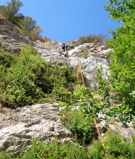
|
|---|
| Lovers Leap - the first rappel (200ft) |
The fire road continues almost flat for a stretch as it passes a second saddle and, 40min from the start, arrives at a third saddle. Here, 1.7mi from the start at 34o15.68'N 118o12.22'W and an elevation of 3300ft, the road divides again. The left fork descends to Grizzly Flats. Take the right fork that climbs gradually, performs one major switchback at 3510ft, and eventually, 3.6mi and 1hr 20 min from the start, arrives at another fire road junction at 34o15.09'N 118o12.45'W and an elevation of 4010ft. The road you now join is the Mount Lukens Road that originates at the Forest Service station on the Angeles Crest Highway just a short distance above La Canada/Flintridge. It comes in from the left and continues on to the right toward Mount Lukens. You turn right and proceed along the road as it follows the ridge that eventually rises to the summit of Mount Lukens (elevation 5074ft). About 2hrs 40min and 6.5mi from the start you will arrive at the summit with its forest of communications towers. Between you and the Big Tujunga far below is a rugged and precipitous descent of about 3200ft.

|
|---|
| The fourth rappel (105ft) |
About 1hr 10min after leaving Mount Lukens and at 34o16.42'N 118o13.89'W and an elevation of about 3700ft you should finally arrive at an open gully with white bedrock; the large white canyon wall will not be too far off to the left. If you reach the 3700ft elevation without encountering such a gully, I suggest contouring left until you do so. Travel down the gully is steep and rocky but reasonably brush-free. At 3430ft the gully joins a larger one entering on the left and you will now have the large white wall on your immediate left. This wall is quite fractured and there appear to be frequent rockslides. At 3240ft you pass a particularly large and recent rockfall.

|
|---|
| The last rappel |
Hike via the Maxon Route
From the Stonyvale Parking Area (34o17.08'N 118o13.40'W and elevation 1840ft) follow the trail (on the north side of the Big Tujunga) eastward for a little over half a mile. There, just after a river crossing, you should be able to discern a faint use-trail that forks right off the main trail at 34o16.76'N 118o13.12'W (elevation 1870ft) and proceeds over to the steep south wall of Big Tujunga. Here the starting point of the very steep use-trail that climbs the ridge to the east of Suicide Canyon should be evident. It begins at 34o16.74'N 118o13.12'W and, though steep, it is well-cleared so not much bush-whacking is required. It is also marked by some faded orange flagging tape. Once you locate the trail it is easily followed, at least initially.
The trail climbs steeply for 500ft where, 50min from the morning start, you will come to a set of utility poles perched on a rocky promontory at 34o16.60'N 118o13.19'W and an elevation of 2390ft. This is a good place to pause, rest and enjoy the view of the Big Tujunga. Beyond the utility poles, the trail traverses along a narrow ridge before resuming the climb through the brush. Here, ropes have been installed in some places to make the climb easier though they are not essential. Finally, about 1hr 30min from the start, the gradient eases and the trail even descends briefly as you cross a brushy flat. It also becomes harder to follow the trail here so a GPS unit is recommended and you should watch for the occasional orange ribbon trail markers in the trees. At 34o16.46'N 118o13.36'W and 2790ft the trail proceeds through the remains of an old and long-abandoned marijuana farm. Here you veer left following the orange ribbon, and shortly after this you veer left again. It helps to keep a watch through the trees and bushes for the white rock wall that runs along the far side of Suicide Canyon off to your right.
You are headed for the place where the trail begins its descent into the canyon at 34o16.48'N 118o13.46'W and an elevation of 2830ft. If you find yourself cliffed out you have lost the trail and need to backtrack and find a trail further upslope. However, once you reach the place where the trail begins to descend it is easy to follow the route down into the Suicide Canyon drainage. You should reach the canyon bottom at 34o16.50'N 118o13.49'W and an elevation of 2780ft about 2hrs after the morning start having travelled just 1.4mi. Just about 30yds downstream from this you arrive at the top of a spectacular overlook with a 200ft abyss directly below you. It is an awesome sight and the start of an exciting rappel descent of the lower section of Suicide Canyon.
Technical Descent on both routes
The dryfall immediately before you is known as Lover's Leap. It consists of hard white rock thankfully free of loose material. It requires a 200ft rope for a rappel from a solid tree on the left side. This descent deposits you in a narrow canyon that is normally dry.
It is only a few yards from the bottom of this big dryfall to the top of the next rappel, a 40ft drop through a V-shaped notch using a convenient tree anchor on the left at the top. A short hike of about 200yds brings you to two more dryfalls, one after the other. The first (elevation 2360ft) is a 25ft rappel from a tree anchor on the left of the lip to a large flat platform with a number of trees. This platform ends in a 90ft rappel (using one of those trees as anchor). Here you may begin to encounter some small pools of water, perhaps enough to filter water if you need it.
Below this big rappel, it is a short hike of about 60yds to a small 25ft drop that had several logs propped up at the bottom. There is a big dead tree stump up on the left of the lip but this did not look like a safe anchor. We used a tree high on the left that needed a short climb to reach it. Another short hike brings you to a 40ft rappel from a tree anchor on the right side of the lip. You should reach this 2150ft elevation about 5hr 40min after leaving the summit of Mount Lukens or, on the Maxon Route, about 2hr from the top of Lover's Leap.
The canyon is now very deep and narrow and at least a trickle of water persists all year long, nourishing the trees and mosses that grow in this lovely part of the canyon. You are now approaching the end of the descent. After a very brief walk, you arrive at a short 20ft rappel from a tree anchor on the left wall of the canyon (elevation 2060ft). Here there was a substantial water drip that provided us with a delightful though limited cold shower. You are now in a narrow defile, perhaps 10ft wide. About 20yds along this passage you come to the top of the last rappel, though it does not look that way from the top. What you see is a 15ft vertical drop to a narrow horizontal platform with another unknown drop beyond that platform. At the top of the 15ft drop there is a solid tree on the left of the narrow lip. Since there are no anchors down on the platform, you should set up a single strand rappel from this tree. Then descend the 15ft to the platform and continue 80ft down to the bottom of the final rappel. You should reach this point (elevation 1930ft) about 6hr 50min after leaving the summit of Mount Lukens or 2hr 20min after arriving at Lover's Leap.
It is just a short 10min hike from the bottom of the final rappel to the exit from Suicide Canyon into the Big Tujunga at 34o16.72'N 118o13.26'W. Turn downstream (left) but quickly make your way across Mill Creek and up the benches on the other side to the main through-canyon trail. It is another 10min hike along that trail (travelling west) to the Stonyvale parking area (34o17.08'N 118o13.40'W and elevation 1840ft) and your vehicle.
The total duration of the route via the summit of Mount Lukens is about 10hr during which you will cover about 8.5mi. The total duration of the hike via the Maxon route is about 6hr during which you will cover about 2.3mi.
Last updated 6/20/07.
Christopher E. Brennen