ADVENTURE HIKES AND CANYONEERING
IN THE SAN GABRIELS
© Christopher Earls Brennen

|
|---|

|
Hike D5. Upper Rubio Canyon
- Hiking time: 5 hours plus access time to Inspiration Point
- Estimated hiking distance: 3.5 miles plus access to Inspiration Point
- Elevation gain: None except for access to Inspiration Point
- USGS Topo Maps: Mount Wilson
- Difficulties: 6 rappels up to 140ft in upper canyon
- Special equipment: 200ft rope, 160ft recovery cord, 60ft webbing, 6 rappel rings
-
ACA Rating: 3B III

Characteristics
The main Rubio Canyon descent described in another chapter constitutes one of the classic canyoneering adventures in the San Gabriel mountains. The seven rappels are all now equipped with good double-bolt anchors that make that descent easier and faster. For the experienced canyoneer, a different adventure in this same canyon is to descend the upper section of Rubio starting at Inspiration Point. This can be terminated where the Castle Canyon Trail crosses Rubio Canyon (34o13.10'N 118o7.10'W and elevation 3390ft), or you could continue down the whole length of Rubio as described in the Rubio Canyon chapter and the extension into upper Rubio described at the end of that chapter.
The adventure described here descends Upper Rubio Canyon, the top being accessed from Inspiration Point. The descent involves 6 rappels plus the 7 in the main canyon if you choose that option. The hike is probably best for a winter, spring or fall day, since it could be very hot in the summer.
Trailhead
This hike begins at Inspiration Point (34o13.39'N 118o6.56'W and elevation 4520ft) and there are a number of different ways to get to this starting point. The natural conclusion to this hike would be to either continue to descend Rubio to the Rubio Canyon trailhead (see the Rubio Canyon chapter) or to follow the Castle Canyon Trail to Mount Echo and then descend the Sam Merrill trail to the trailhead at Lake and Loma Alta in Altadena (see the starting point for the Rubio Canyon descent in the Rubio Canyon chapter).
If you choose to access Inspiration Point from the Lake and Loma Alta trailhead via the Sam Merrill Trail, Mount Echo and the Castle Canyon trail, that approach involves a substantial elevation gain of 2700ft, a hike that takes about 2hrs 40min. An alternative would be a lengthy car shuttle to Eaton Saddle (34o14.36'N 118o5.60'W and elevation 5090ft) and then a 1hr 10min hike down the fire road to Inspiration Point. In this description the times and distances are given from the Inspiration Point start.
Hike

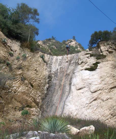
|
|---|
| Third rappel |
Setting out from Inspiration Point, you should follow the rough use trail up the ridge immediately west of Inspiration Point. In a few minutes you should reach the 4714ft summit adorned with various artifacts from the days of the Mount Lowe Tavern. From the summit, continue along the ridgeline as it veers south. Beyond one small rise, there is a short stretch of difficult buckthorn bushwhacking but the use-trail on the ridgeline resumes after this and soon you will arrive at the afore-mentioned drop-in saddle, readily recognized by the group of pine trees off to the right. You should reach this drop-in saddle at 34o13.24'N 118o6.79'W and an elevation of 4450ft about 45min after leaving Inspiration Point. Whereas any attempt to leave the ridge prior to this would encounter thick brush, the slope west from this drop-in saddle is remarkably clear of brush and allows easy descent into a gully that eventually leads down into Upper Rubio Canyon.
As the gully deepens there are several small downclimbs and, about 4000ft the old electricity wires that litter this canyon make their first appearance. These wires are not only unsightly but can pose an additional hazard on some of the rappels. They could and should be removed. Just downstream of this at 3990ft and 1hr 45min from Inspiration Point you arrive at the top of the first rappel, a clean 100ft two-step drop from a bush anchor on the left. This could be broken up into two rappels since there are good anchors on the intermediate shelf but a 200ft rope will just allow a combined double-rope descent. This drop is immediately followed by the second rappel, a 140ft drop from an anchor bush high on the right of the lip. Here the wires are a menace and care must be taken that the ropes do not get entangled with them. Care must also be taken to set up a successful rope pull. It is just a few yards downstream to the last of this series of rappels, a 60ft sloping rappel from a bush on the left.
|
|---|
| Fourth rappel |
From the bottom of this last rappel it is less than a hundred yards to the place where the Castle Canyon Trail crosses Rubio Canyon. This is located at 34o13.10'N 118o7.10'W and an elevation of 3400ft. You should reach this point about 3hrs 45min after leaving Inspiration Point having covered about 0.8mi.
If you have decided to proceed on down Rubio Canyon then that descent is covered in the chapter on Rubio Canyon. If, on the other hand, this is enough for the day then you should follow the Castle Canyon Trail as it contours out of the canyon bottom to the right. It is a 15min and 0.5mi hike back to Echo Mountain (34o12.74'N 118o7.30'W and 3200ft). From there it takes an additional hour to descend the 3mi of the Sam Merrill Trail down to the trailhead at the top of Lake Avenue in Altadena (34o12.25'N 118o7.83'W and 1800ft). Thus the total duration of the descent from Inspiration Point is about 5hr.
Last updated 13/24/07.
Christopher E. Brennen